A Collection of Maps Exhibiting the Changing Political Landscape in Beleriand by Artano
Fanwork Notes
These maps are not meant to show every single single political shift, but are generally broader strokes. In addition, there could be inaccuracies as I was skimming The Silmarillion to look for pertinent parts. I apologize if there are any, and if you see some, please let me know; I will update the descriptions to include them.
Fanwork Information
|
Description: Created for the 'Geography/Maps/Places' prompt on the "Tolkien meta" bingo board, this is a collection of maps marked with the various people groups showing how they arrived and moved about Beleriand. This collection focuses specifically on the time from the arrival of the Teleri, Vanyar, and Noldor before they went to Aman up to the distribution of the various kingdoms after the Flight of the Noldor, when they arrived in Middle-earth and settled there. Major Characters: Sindar, Noldor, Vanyar, Petty-dwarves, Dwarves, Orcs, Falathrim, Doriathrim, Laiquendi, Ungoliant, Green-elves Major Relationships: Genre: General Type: Landscape Challenges: Potluck Bingo Rating: General Warnings: |
|
| Posted on 18 November 2024 | Updated on 18 November 2024 |
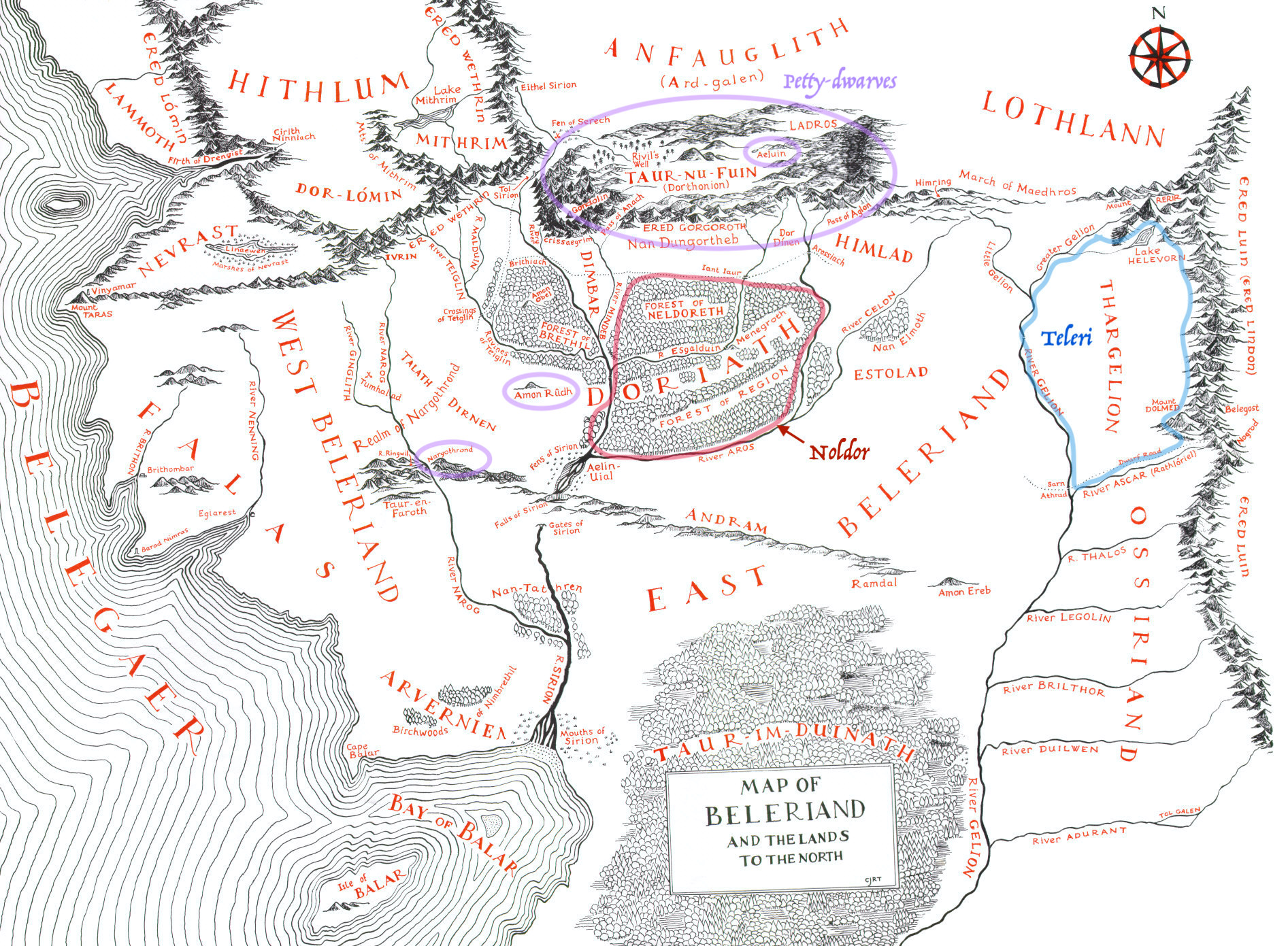
Distribution of Noldor and Teleri after arriving in Beleriand
Chapter End Notes
This map shows the general distribution of the Teleri, Noldor, and Petty-dwarves soon after the Elves crossed into Beleriand. The Vanyar were not mentioned int he part of the text I read, but presumably they are with the Noldor.
The Petty-dwarves are included here because according to The History off Middle-earth, the Petty-dwarves settled in Beleriand, specifically Dorthonion, before the Elves crossed the mountains and entered it. Tarn Aeliun is circled with a smaller circle because in Mîm's Klage, Mîm is said to have lived there. (However, Mîm's Klage is generally not considered canon from what I am aware, and it does present a contradiction in the form of how long dwarves can live if one accepts it as canon in its entirety. That said, I do not think it unlikely that Petty-dwarves lived near it, as it was a freshwater lake in an area they are known to have inhabited. But that is conjecture.). In addition, we have no knowledge of whether the Petty-dwarves had at this time yet settled in Amon Rûdh and Nargothrond; they are marked purely to show where the Petty-dwarves might have been at this point.
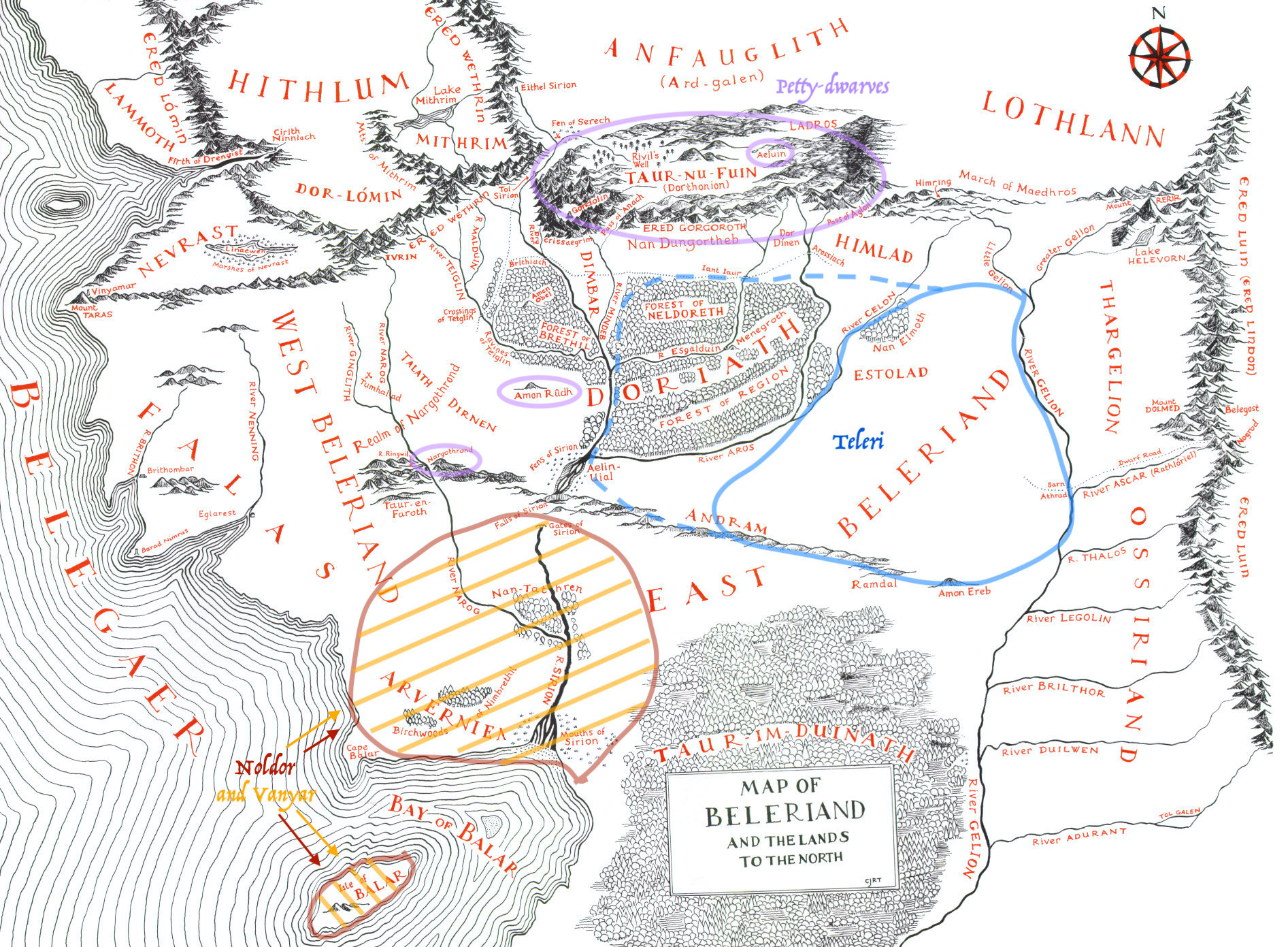
Chapter End Notes
This map shows the general distribution of the Teleri, Vanyar, Noldor, and Petty-dwarves as the Vanyar and Noldor were led by Oromë to the lands around the Sirion. The Teleri had at this point crossed into East Beleriand, and many were searching for Thingol when the Noldor and Vanyar moved onto the island Ulmo moved into the Bay of Balar. (In this map, I represented that by marking the Isle of Balar.). The dotted blue line indicates that it is possible the Teleri ventured into Doriath at this time, in search for Thingol, though that is not stated.
See the previous map for notes on the Petty-dwarves.
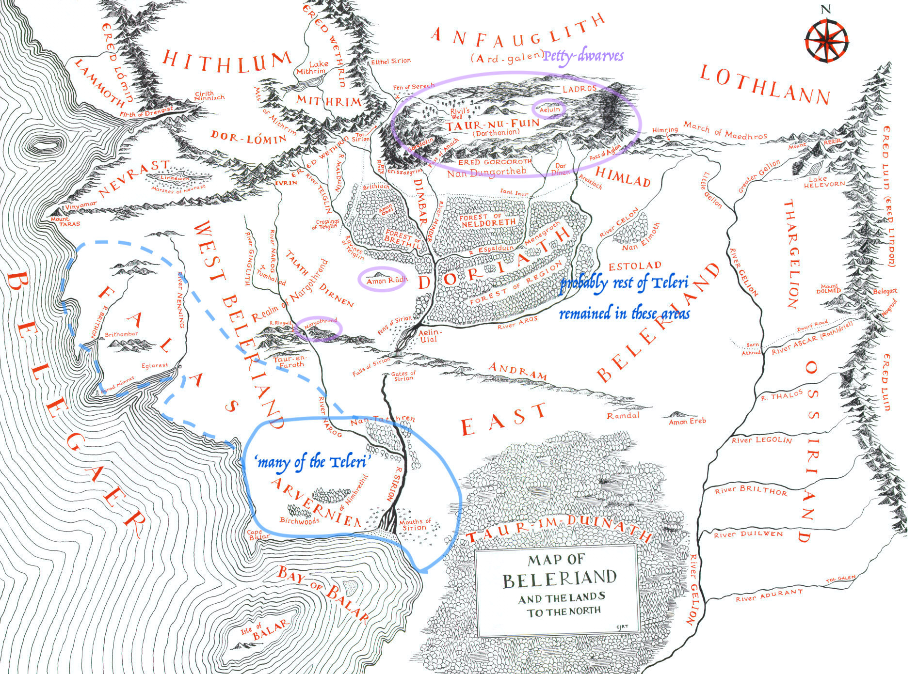
Chapter End Notes
This map shows the general distribution of the Teleri and Petty-dwarves after the Vanyar and Noldor left Beleriand for Aman. "But when they learned that Ingwë and Finwë and their peoples were gone, then many of the Teleri pressed on to the shores of Beleriand, and dwelt thereafter near the Mouths of Sirion, in longing for their friends that had departed..." - The Silmarillion The dotted lines represent a possible expansion of the Teleri, as they began moving into Falas and collecting under Círdan. But again, this is conjecture. Since the text says. that "many of the Teleri pressed on to the shores", implying that at least some remained in the areas they were previously inhabiting (as is later confirmed by the text stating that Elves still searched in those areas for Thingol), marked by the note on the map.
See previous maps for notes on the Petty-dwarves.
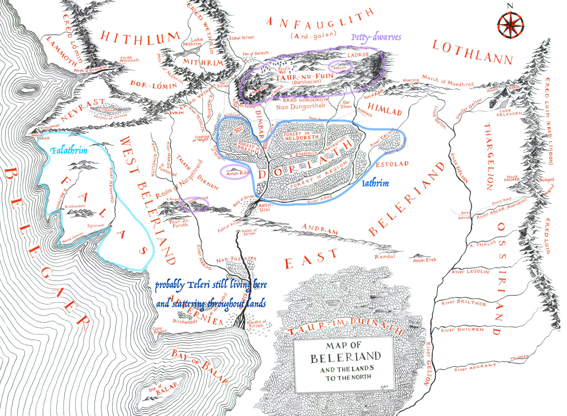
Chapter End Notes
This map shows the general distribution of the Teleri and Petty-dwarves after the rest of the Teleri left Beleriand for Aman. At this point, the Teleri who remained seemed mostly to divide into those that followed Círdan as their lord and settled in Falas, and those friends of Thingol who remained in the Hither Lands, searching for him. They possibly lived outside of Doriath, and from what I remember, it is not known for sure whether they searched there (though I think I remember it mentioning that those searching for him searched in forests, which would likely include Doriath, especially since that was the place he was originally traveling to). However, I marked that area as it is a place that their people become centralized at after Thingol returns. In addition, the note on Teleri still living near the mouth of the Sirion and beginning to scatter throughout Beleriand is purely conjecture, anticipating the occurrences in the next map.
See previous maps for notes on the Petty-dwarves.
There is an inaccuracy on this map; the people labeled 'Iathrim' would more accurately be labeled 'Eglath', as that was what they called themselves.
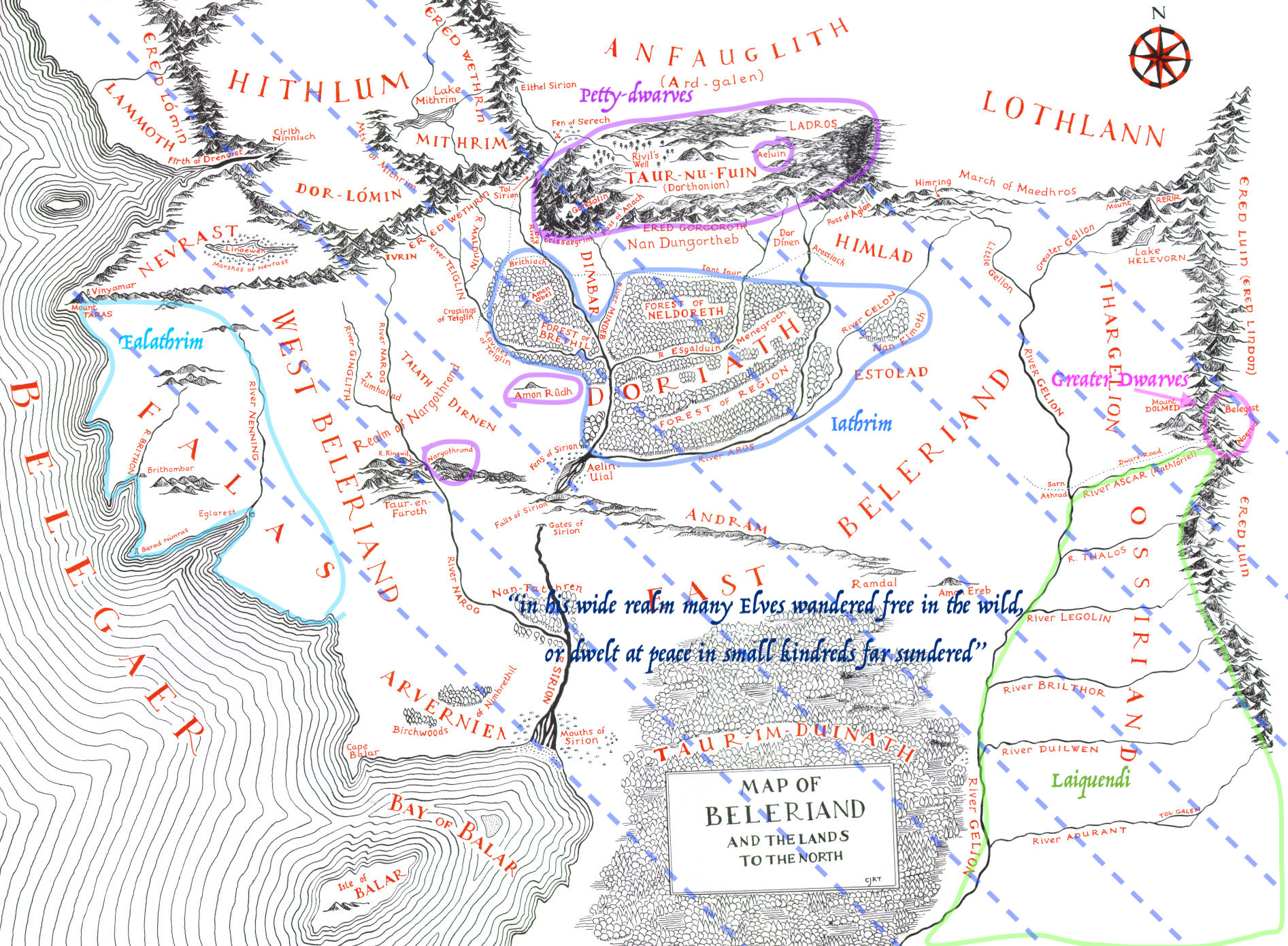
Chapter End Notes
This map shows the general distribution of the Teleri, Lauquendi, Petty-dwarves, and Greater Dwarves after Thingol's re-emergence and taking up the crown over all Teleri. At this point, almost the entirety of Beleriand is said to be Thingol's realm, represented by the blue dashed lines. Within this are, many elves wander, but they are centralized under Círdan in Falas and under Thingol in Doriath. The Laiquendi also come up form the south and settle in Ossiriand.
In addition, the Greater Dwarves enter Beleriand, emerging from their cities in the mountains and discover the Elves have been hunting their kindred. By this time, the Petty-dwarves have been hunted almost to extinction. Thus, they likely no longer remained in Dorthonion, though that is conjecture. (I did not reflect this conjecture in the map.) I am unsure when the hunting of the petty-dwarves would have begun, but since they only have a Sindarin name, it is possible that they were only discovered sometime after the Noldor and Vanyar left for Aman.
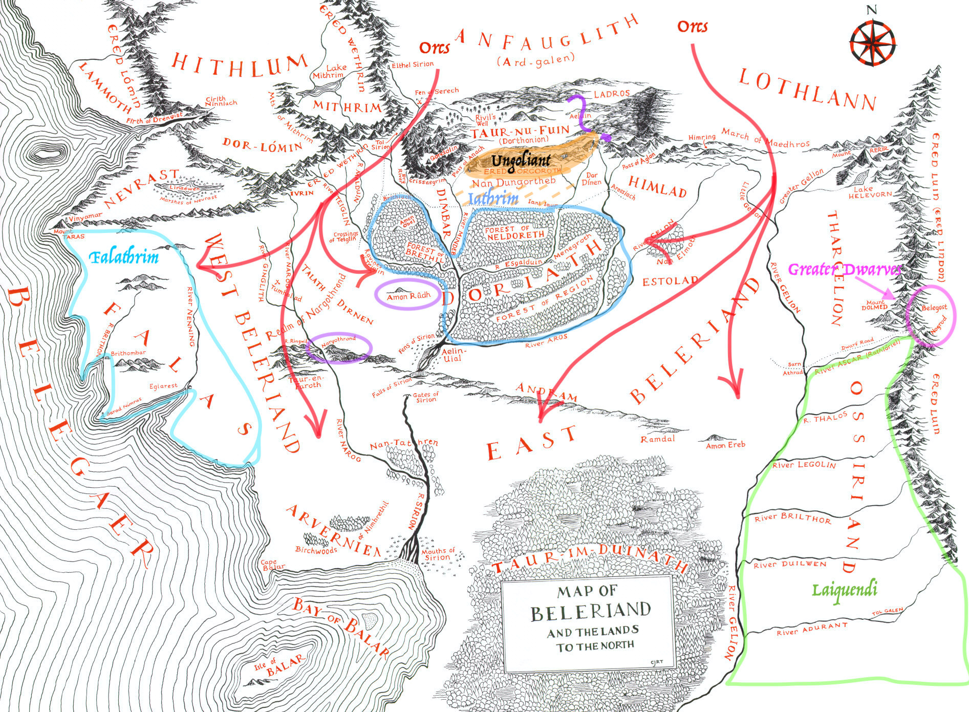
Chapter End Notes
This map shows the general distribution of the Teleri, Lauquendi, Petty-dwarves, Greater Dwarves, Orcs, and Ungoliant after the Darkening of Valinor and Morgoth's flight to Middle-earth. At this point, Ungoliant has taken up residence in the Ered Gorgoroth. The dashed lines filling the space between them and the edge of Doriath represent the extent of her and her offspring's possible range; since that road was know to be dangerous and taken only at great need, it implies that they reached that far.
The red arrows represent the orc's invasion of Beleriand after Morgoth's return.
And the Petty-dwarves' uncertain status in Dorthonion (see previous map's note for details) is represented by the purple question mark.
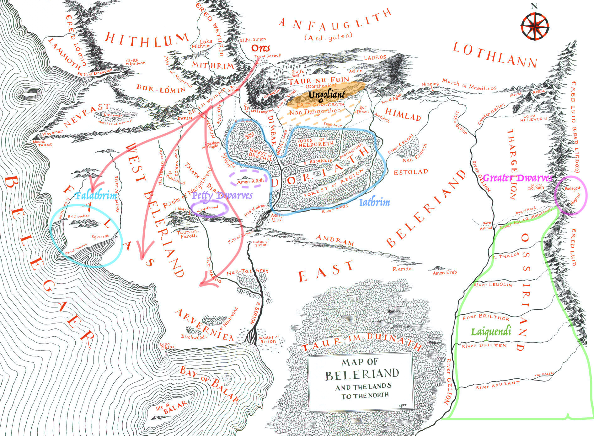
Chapter End Notes
This map shows the general distribution of the Teleri, Lauquendi, Petty-dwarves, Greater Dwarves, Orcs, and Ungoliant after Thingol and the Laiquendi defeated the orcs in East Beleriand. At this point, Cirdan and his people are driven to the rim of the sea (possibly referring to Brithombar and Eglarest?). Thingol retreats to Doriath, and the Gridle of Melian is created.
The dotted purple line around Amon Rûdh represents the uncertain status of the Petty-dwarves there. It was there home at one point, but the only time we see Petty-dwarves living there is when Mîm and his sons living there. (If I am remembering correctly, after being kicked out of Nargthrond, according to The History of Middle-earth.)
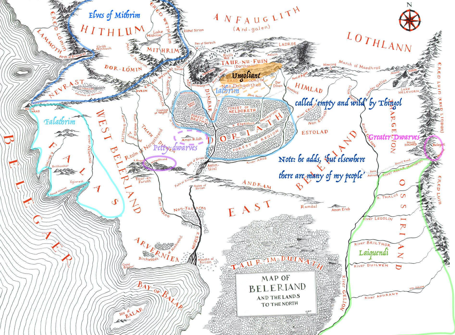
Chapter End Notes
This map shows the general distribution of the Teleri, Lauquendi, Petty-dwarves, Greater Dwarves, Orcs, and Ungoliant after the arrival of the Noldor and their defeating the orcs in East Beleriand. This is before the dividing of the lands among the Noldor, so I chose not to represent them on this map. For notes on other people groups, see previous maps.
Chapter End Notes
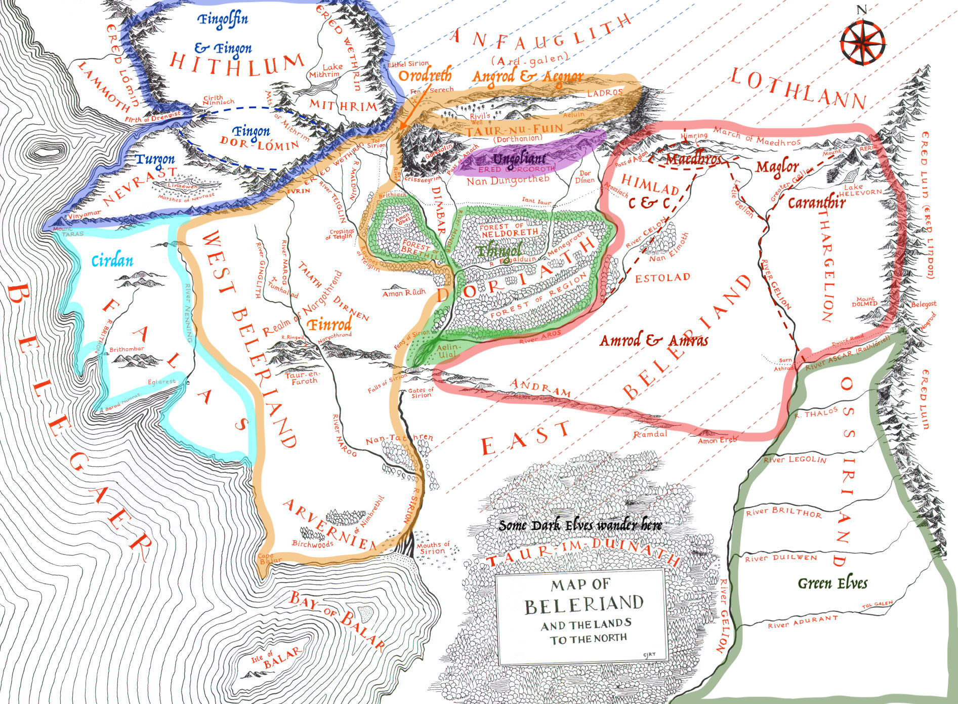
This map shows the general distribution of the Teleri, Lauquendi, Noldor, and Ungoliant after the dividing of the land among the Noldor. The red area shows the land under control of the sons of Feanor: Specific territories for each son are outlined with dashed lines and labelled; dashed lines extending beyond the territory shows areas they are mentioned wandering/being in, but are not specifically said to have been their realms. The orange area shows the land under control of the sons of Finarfin: Sspecific territories for each son are labelled. The dark blue area shows the land under control of Fingolfin and his sons: Specific territories for each person are outlined with dashed lines and labelled; dashed lines extending beyond the territory shows areas they are mentioned wandering/being in, but are not specifically said to have been their realms.
The green area shows Thingol's territory, and the sea green/lighter blue shows Círdan's territory. And the black wording shows the area the Dark Elves are said to wander in.
Finally, purple represents the area under control of Ungoliant and her offspring. (Note: I forgot to include the dashed lines extending to the border of Doriath in this one.)
In addition, I did not include either of the Dwarves, though the Greater Dwarves are still in the same place. And at this point, the Petty-dwarves are almost extinct, with only Mîm and his two sons living in (presumably) Amon Rúdh.


Comments on A Collection of Maps Exhibiting the Changing Political Landscape in Beleriand
The Silmarillion Writers' Guild is more than just an archive--we are a community! If you enjoy a fanwork or enjoy a creator's work, please consider letting them know in a comment.
Artano has requested the following types of constructive criticism on this fanwork: Accuracy, Flow, Presentation, Style, Technique, Fulfilled Intent, Organization/Structure, Pacing, Research. All constructive criticism must follow our diplomacy guidelines.